Digitizing Rail for Track Optimization and Construction
Whether it's hauling freight across the continent or commuters across the city, a railroad is only as good as its tracks. Railroad tracks move over time as the Earth and tracks' ballast shifts, meaning that a railroad's right-of-way looks different today than it did when it was first constructed. When it comes to making repairs in the right-of-way, railroad companies and transit systems cannot simply rely on their original plans; they need an up-to-date view of the line as it exists today. Bringing the track environment into the digital world helps rail network providers analyze, manage, and optimize the infrastructure without the need for costly and regular on-site deployment of resources.
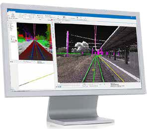
Hexagon's rail solutions enable digitization, helping providers quickly identify changes, recognize weaknesses, mitigate risks and, most importantly, plan — all crucial steps to the safe and efficient transportation of passengers and freight. For both high rail and trolley surveying applications, our high-precision imaging, laser, and radar sensors coupled with innovative software allows the capture, measurement, analysis, and visualization of the track environment to support optimization and new construction.
|